|
|
|||||||||||||||||
| Point ID: 6562 | Downloads | Plots | Site Data | Code: 9164 |
|
|
|||||||||||||||||
| Download | |
|---|---|
| Site Descriptor Information | Site Time Series Data |
| Link to all available data | |
| View: | Time Series | All |
| Units: | m3/s |
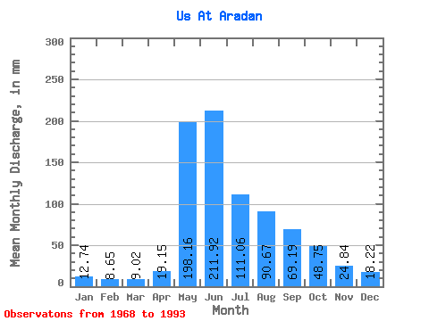
| Statistic | Jan | Feb | Mar | Apr | May | Jun | Jul | Aug | Sep | Oct | Nov | Dec | Annual |
|---|---|---|---|---|---|---|---|---|---|---|---|---|---|
| Mean | 12.74 | 8.72 | 9.02 | 19.14 | 198.13 | 211.92 | 111.05 | 90.65 | 69.19 | 48.75 | 24.84 | 18.22 | 819.07 |
| Standard Deviation | 2.10 | 2.42 | 3.34 | 9.39 | 67.57 | 91.72 | 40.09 | 32.02 | 19.88 | 16.49 | 5.01 | 2.33 | 157.83 |
| Min | 8.37 | 4.01 | 3.87 | 5.00 | 94.37 | 88.46 | 45.70 | 33.37 | 35.18 | 27.84 | 17.51 | 14.58 | 524.48 |
| Max | 16.09 | 12.45 | 15.18 | 37.44 | 346.44 | 464.91 | 225.29 | 156.85 | 106.56 | 107.12 | 37.23 | 23.17 | 1095.71 |
| Coefficient of Variation | 0.17 | 0.28 | 0.37 | 0.49 | 0.34 | 0.43 | 0.36 | 0.35 | 0.29 | 0.34 | 0.20 | 0.13 | 0.19 |
 Return to R-Arctic Net Home Page