|
|
|||||||||||||||||
| Point ID: 6562 | Downloads | Plots | Site Data | Code: 9164 |
|
|
|||||||||||||||||
| Download | |
|---|---|
| Site Descriptor Information | Site Time Series Data |
| Link to all available data | |
|
|
| View: | Statistics | Time Series |
| Units: | m3/s |
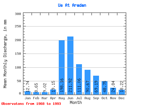
| Statistic | Jan | Feb | Mar | Apr | May | Jun | Jul | Aug | Sep | Oct | Nov | Dec | Annual |
|---|---|---|---|---|---|---|---|---|---|---|---|---|---|
| Mean | 12.74 | 8.72 | 9.02 | 19.14 | 198.13 | 211.92 | 111.05 | 90.65 | 69.19 | 48.75 | 24.84 | 18.22 | 819.07 |
| Standard Deviation | 2.10 | 2.42 | 3.34 | 9.39 | 67.57 | 91.72 | 40.09 | 32.02 | 19.88 | 16.49 | 5.01 | 2.33 | 157.83 |
| Min | 8.37 | 4.01 | 3.87 | 5.00 | 94.37 | 88.46 | 45.70 | 33.37 | 35.18 | 27.84 | 17.51 | 14.58 | 524.48 |
| Max | 16.09 | 12.45 | 15.18 | 37.44 | 346.44 | 464.91 | 225.29 | 156.85 | 106.56 | 107.12 | 37.23 | 23.17 | 1095.71 |
| Coefficient of Variation | 0.17 | 0.28 | 0.37 | 0.49 | 0.34 | 0.43 | 0.36 | 0.35 | 0.29 | 0.34 | 0.20 | 0.13 | 0.19 |
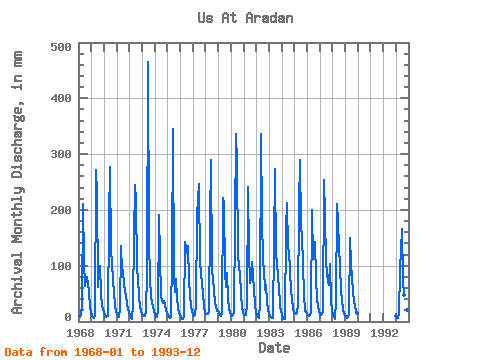
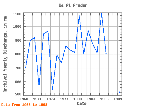
| Year | Jan | Feb | Mar | Apr | May | Jun | Jul | Aug | Sep | Oct | Nov | Dec | Annual | 1968 | 9.61 | 7.49 | 12.88 | 29.62 | 216.79 | 109.23 | 65.89 | 76.09 | 80.02 | 55.90 | 23.25 | 18.77 | 701.50 | 1969 | 9.99 | 7.13 | 6.14 | 11.87 | 280.55 | 230.40 | 63.12 | 89.05 | 98.95 | 52.71 | 27.77 | 23.17 | 897.41 | 1970 | 16.09 | 10.52 | 8.29 | 9.01 | 188.95 | 277.71 | 130.29 | 109.67 | 72.82 | 53.77 | 28.18 | 19.49 | 921.86 | 1971 | 14.60 | 10.73 | 9.12 | 22.42 | 140.49 | 88.46 | 95.64 | 66.74 | 44.02 | 34.22 | 21.39 | 18.36 | 562.82 | 1972 | 12.65 | 6.00 | 5.23 | 31.68 | 159.19 | 244.80 | 225.29 | 97.77 | 78.38 | 45.27 | 25.51 | 18.60 | 946.30 | 1973 | 13.88 | 9.88 | 9.46 | 17.28 | 94.37 | 464.91 | 151.97 | 76.94 | 45.46 | 34.64 | 26.74 | 19.04 | 966.29 | 1974 | 13.35 | 8.37 | 7.52 | 19.48 | 196.81 | 117.46 | 45.70 | 33.37 | 37.03 | 31.24 | 19.89 | 15.49 | 543.05 | 1975 | 12.24 | 8.07 | 6.46 | 7.51 | 119.23 | 345.60 | 81.40 | 53.77 | 76.53 | 43.15 | 23.66 | 15.09 | 794.05 | 1976 | 8.37 | 4.94 | 4.08 | 9.91 | 146.65 | 131.25 | 127.31 | 139.64 | 71.18 | 50.80 | 25.10 | 21.68 | 735.84 | 1977 | 11.65 | 9.97 | 11.95 | 28.80 | 194.90 | 246.86 | 106.69 | 92.24 | 63.15 | 53.77 | 25.71 | 15.26 | 858.36 | 1978 | 14.13 | 12.45 | 13.50 | 17.57 | 185.34 | 290.06 | 95.22 | 78.85 | 53.90 | 33.37 | 18.84 | 19.60 | 831.48 | 1979 | 15.64 | 11.39 | 10.37 | 15.08 | 229.54 | 209.83 | 91.39 | 63.97 | 87.02 | 42.30 | 22.01 | 16.39 | 812.29 | 1980 | 12.60 | 9.02 | 11.86 | 16.73 | 346.44 | 281.83 | 123.91 | 100.74 | 85.37 | 50.16 | 26.54 | 18.05 | 1078.07 | 1981 | 12.01 | 12.08 | 11.12 | 29.01 | 248.67 | 123.22 | 71.41 | 80.98 | 106.56 | 59.72 | 30.24 | 18.49 | 799.69 | 1982 | 11.50 | 7.47 | 5.87 | 32.91 | 346.44 | 183.70 | 112.01 | 95.64 | 55.75 | 67.59 | 35.38 | 22.10 | 969.61 | 1983 | 15.64 | 9.28 | 7.80 | 6.23 | 142.83 | 273.60 | 121.78 | 111.16 | 75.91 | 64.83 | 28.39 | 18.43 | 873.58 | 1984 | 13.71 | 4.01 | 3.87 | 5.00 | 172.16 | 211.89 | 135.60 | 130.07 | 56.16 | 42.08 | 23.25 | 16.32 | 809.56 | 1985 | 15.66 | 11.95 | 15.18 | 29.62 | 214.66 | 290.06 | 175.98 | 156.85 | 103.06 | 48.67 | 18.41 | 19.79 | 1095.71 | 1986 | 13.30 | 9.68 | 12.90 | 17.46 | 205.74 | 111.50 | 130.50 | 147.93 | 78.58 | 41.87 | 25.10 | 18.83 | 807.33 | 1987 | 12.82 | 11.04 | 13.47 | 18.41 | 261.42 | 191.73 | 108.39 | 72.90 | 65.83 | 107.12 | 37.23 | 19.60 | 914.74 | 1988 | 12.77 | 7.76 | 4.93 | 37.44 | 216.79 | 180.82 | 135.18 | 105.21 | 53.28 | 40.59 | 20.98 | 14.58 | 825.74 | 1989 | 9.80 | 5.87 | 8.48 | 13.02 | 154.30 | 102.65 | 82.68 | 55.47 | 35.18 | 27.84 | 17.51 | 15.09 | 524.48 | 1993 | 10.99 | 5.54 | 7.01 | 14.26 | 94.79 | 166.63 | 76.73 | 49.95 | 67.27 | 39.53 | 20.28 | 16.77 | 568.81 |
|---|
 Return to R-Arctic Net Home Page