|
|
|||||||||||||||||
| Point ID: 6560 | Downloads | Plots | Site Data | Code: 9156 |
|
|
|||||||||||||||||
| Download | |
|---|---|
| Site Descriptor Information | Site Time Series Data |
| Link to all available data | |
| View: | Time Series | All |
| Units: | m3/s |
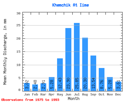
| Statistic | Jan | Feb | Mar | Apr | May | Jun | Jul | Aug | Sep | Oct | Nov | Dec | Annual |
|---|---|---|---|---|---|---|---|---|---|---|---|---|---|
| Mean | 3.02 | 2.50 | 2.91 | 5.28 | 12.43 | 23.90 | 25.84 | 20.30 | 13.54 | 8.76 | 5.29 | 3.61 | 125.48 |
| Standard Deviation | 0.41 | 0.43 | 0.47 | 1.40 | 2.62 | 6.95 | 9.06 | 5.60 | 4.08 | 2.07 | 1.00 | 0.64 | 20.83 |
| Min | 2.59 | 1.95 | 1.95 | 3.61 | 8.58 | 12.91 | 11.97 | 13.86 | 8.39 | 6.15 | 3.35 | 2.01 | 97.11 |
| Max | 3.96 | 3.63 | 3.69 | 8.22 | 15.65 | 36.19 | 46.52 | 30.67 | 22.77 | 13.86 | 6.64 | 4.60 | 169.07 |
| Coefficient of Variation | 0.14 | 0.17 | 0.16 | 0.26 | 0.21 | 0.29 | 0.35 | 0.28 | 0.30 | 0.24 | 0.19 | 0.18 | 0.17 |
 Return to R-Arctic Net Home Page