|
|
|||||||||||||||||
| Point ID: 6560 | Downloads | Plots | Site Data | Code: 9156 |
|
|
|||||||||||||||||
| Download | |
|---|---|
| Site Descriptor Information | Site Time Series Data |
| Link to all available data | |
| View: | Time Series | All |
| Units: | mm |
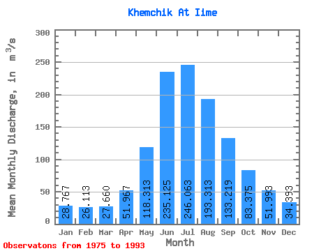
| Statistic | Jan | Feb | Mar | Apr | May | Jun | Jul | Aug | Sep | Oct | Nov | Dec | Annual |
|---|---|---|---|---|---|---|---|---|---|---|---|---|---|
| Mean | 28.77 | 26.11 | 27.66 | 51.97 | 118.31 | 235.12 | 246.06 | 193.31 | 133.22 | 83.38 | 51.99 | 34.39 | 101.39 |
| Standard Deviation | 3.88 | 4.52 | 4.44 | 13.73 | 24.94 | 68.35 | 86.27 | 53.32 | 40.15 | 19.71 | 9.82 | 6.08 | 16.83 |
| Min | 24.70 | 20.40 | 18.60 | 35.50 | 81.70 | 127.00 | 114.00 | 132.00 | 82.50 | 58.60 | 33.00 | 19.10 | 78.47 |
| Max | 37.70 | 37.90 | 35.10 | 80.90 | 149.00 | 356.00 | 443.00 | 292.00 | 224.00 | 132.00 | 65.30 | 43.80 | 136.61 |
| Coefficient of Variation | 0.14 | 0.17 | 0.16 | 0.26 | 0.21 | 0.29 | 0.35 | 0.28 | 0.30 | 0.24 | 0.19 | 0.18 | 0.17 |
 Return to R-Arctic Net Home Page