|
|
|||||||||||||||||
| Point ID: 656 | Downloads | Plots | Site Data | Other Close Sites | Code: 07BC002 |
|
|
|||||||||||||||||
| Download | |
|---|---|
| Site Descriptor Information | Site Time Series Data |
| Link to all available data | |
| View: | Time Series | All |
| Units: | m3/s |
| Statistic | Jan | Feb | Mar | Apr | May | Jun | Jul | Aug | Sep | Oct | Nov | Dec | Annual |
|---|---|---|---|---|---|---|---|---|---|---|---|---|---|
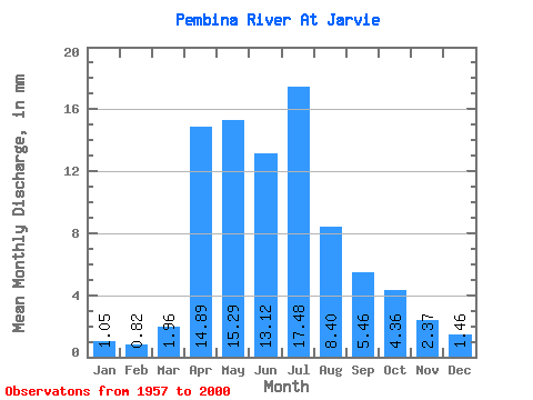
| Mean | 1.01 | 0.80 | 1.88 | 14.32 | 14.70 | 12.62 | 16.81 | 8.08 | 5.26 | 4.19 | 2.28 | 1.41 | 86.83 |
| Standard Deviation | 0.49 | 0.34 | 1.76 | 11.08 | 10.48 | 9.63 | 14.48 | 7.33 | 3.94 | 2.91 | 1.21 | 0.80 | 40.71 |
| Min | 0.14 | 0.16 | 0.34 | 1.79 | 2.08 | 2.99 | 1.73 | 0.92 | 0.82 | 0.94 | 0.45 | 0.17 | 32.86 |
| Max | 2.41 | 1.56 | 7.71 | 61.14 | 59.08 | 46.89 | 65.62 | 44.36 | 18.88 | 13.06 | 5.42 | 3.33 | 203.73 |
| Coefficient of Variation | 0.48 | 0.43 | 0.94 | 0.77 | 0.71 | 0.76 | 0.86 | 0.91 | 0.75 | 0.69 | 0.53 | 0.57 | 0.47 |
| Other Close Sites | ||||||
|---|---|---|---|---|---|---|
| PointID | Latitude | Longitude | Drainage Area | Source | Name | |
| 655 | "PEMBINA RIVER NEAR DAPP" | 54.35 | 1587140 | Hydat | ||
 Return to R-Arctic Net Home Page