|
|
|||||||||||||||||
| Point ID: 6550 | Downloads | Plots | Site Data | Code: 9118 |
|
|
|||||||||||||||||
| Download | |
|---|---|
| Site Descriptor Information | Site Time Series Data |
| Link to all available data | |
| View: | Time Series | All |
| Units: | m3/s |
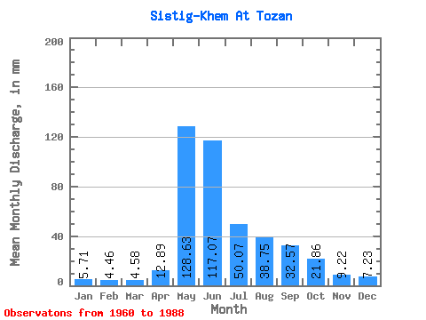
| Statistic | Jan | Feb | Mar | Apr | May | Jun | Jul | Aug | Sep | Oct | Nov | Dec | Annual |
|---|---|---|---|---|---|---|---|---|---|---|---|---|---|
| Mean | 5.71 | 4.50 | 4.58 | 12.88 | 128.61 | 117.07 | 50.07 | 38.74 | 32.57 | 21.86 | 9.22 | 7.23 | 431.09 |
| Standard Deviation | 2.54 | 2.14 | 1.78 | 9.37 | 33.91 | 62.62 | 17.91 | 13.98 | 14.65 | 10.97 | 4.01 | 3.01 | 92.38 |
| Min | 1.40 | 0.88 | 1.11 | 1.75 | 84.03 | 39.44 | 20.67 | 14.75 | 15.91 | 9.97 | 2.52 | 1.38 | 278.14 |
| Max | 11.12 | 9.97 | 8.52 | 39.20 | 204.33 | 300.74 | 81.61 | 75.56 | 79.57 | 66.50 | 16.44 | 12.76 | 632.45 |
| Coefficient of Variation | 0.44 | 0.47 | 0.39 | 0.73 | 0.26 | 0.54 | 0.36 | 0.36 | 0.45 | 0.50 | 0.43 | 0.42 | 0.21 |
 Return to R-Arctic Net Home Page