|
|
|||||||||||||||||
| Point ID: 6550 | Downloads | Plots | Site Data | Code: 9118 |
|
|
|||||||||||||||||
| Download | |
|---|---|
| Site Descriptor Information | Site Time Series Data |
| Link to all available data | |
| View: | Time Series | All |
| Units: | mm |
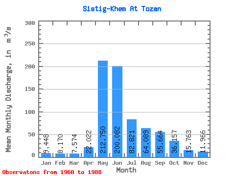
| Statistic | Jan | Feb | Mar | Apr | May | Jun | Jul | Aug | Sep | Oct | Nov | Dec | Annual |
|---|---|---|---|---|---|---|---|---|---|---|---|---|---|
| Mean | 9.45 | 8.17 | 7.57 | 22.02 | 212.75 | 200.08 | 82.82 | 64.09 | 55.66 | 36.16 | 15.76 | 11.97 | 60.51 |
| Standard Deviation | 4.20 | 3.88 | 2.94 | 16.01 | 56.10 | 107.02 | 29.62 | 23.12 | 25.04 | 18.15 | 6.86 | 4.98 | 12.97 |
| Min | 2.32 | 1.60 | 1.83 | 2.99 | 139.00 | 67.40 | 34.20 | 24.40 | 27.20 | 16.50 | 4.30 | 2.29 | 39.04 |
| Max | 18.40 | 18.10 | 14.10 | 67.00 | 338.00 | 514.00 | 135.00 | 125.00 | 136.00 | 110.00 | 28.10 | 21.10 | 88.78 |
| Coefficient of Variation | 0.44 | 0.47 | 0.39 | 0.73 | 0.26 | 0.54 | 0.36 | 0.36 | 0.45 | 0.50 | 0.43 | 0.42 | 0.21 |
 Return to R-Arctic Net Home Page