|
|
|||||||||||||||||
| Point ID: 6549 | Downloads | Plots | Site Data | Code: 9117 |
|
|
|||||||||||||||||
| Download | |
|---|---|
| Site Descriptor Information | Site Time Series Data |
| Link to all available data | |
| View: | Time Series | All |
| Units: | m3/s |
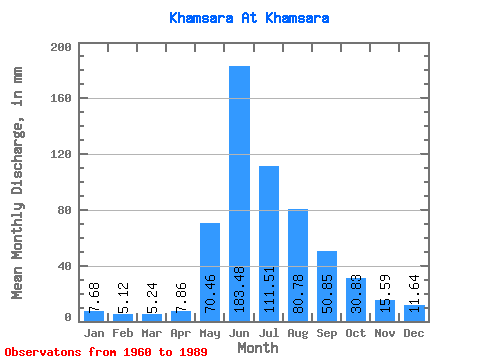
| Statistic | Jan | Feb | Mar | Apr | May | Jun | Jul | Aug | Sep | Oct | Nov | Dec | Annual |
|---|---|---|---|---|---|---|---|---|---|---|---|---|---|
| Mean | 7.68 | 5.16 | 5.24 | 7.86 | 70.45 | 183.48 | 111.50 | 80.77 | 50.85 | 30.83 | 15.59 | 11.64 | 579.77 |
| Standard Deviation | 1.40 | 1.91 | 1.84 | 2.90 | 30.97 | 44.30 | 32.35 | 24.62 | 12.76 | 8.38 | 4.58 | 2.58 | 79.66 |
| Min | 5.53 | 3.41 | 2.79 | 4.20 | 25.03 | 119.26 | 49.89 | 41.79 | 29.21 | 16.81 | 8.85 | 6.41 | 455.22 |
| Max | 10.52 | 13.07 | 11.77 | 16.80 | 141.29 | 296.83 | 195.51 | 135.82 | 87.46 | 62.43 | 24.44 | 17.31 | 729.76 |
| Coefficient of Variation | 0.18 | 0.37 | 0.35 | 0.37 | 0.44 | 0.24 | 0.29 | 0.30 | 0.25 | 0.27 | 0.29 | 0.22 | 0.14 |
 Return to R-Arctic Net Home Page