|
|
|||||||||||||||||
| Point ID: 6549 | Downloads | Plots | Site Data | Code: 9117 |
|
|
|||||||||||||||||
| Download | |
|---|---|
| Site Descriptor Information | Site Time Series Data |
| Link to all available data | |
| View: | Time Series | All |
| Units: | mm |
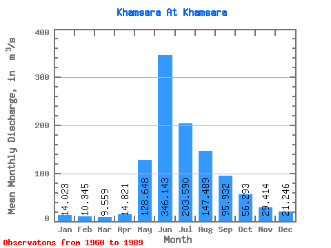
| Statistic | Jan | Feb | Mar | Apr | May | Jun | Jul | Aug | Sep | Oct | Nov | Dec | Annual |
|---|---|---|---|---|---|---|---|---|---|---|---|---|---|
| Mean | 14.02 | 10.35 | 9.56 | 14.82 | 128.65 | 346.14 | 203.59 | 147.49 | 95.93 | 56.29 | 29.41 | 21.25 | 89.83 |
| Standard Deviation | 2.56 | 3.82 | 3.36 | 5.46 | 56.55 | 83.57 | 59.08 | 44.95 | 24.07 | 15.30 | 8.64 | 4.71 | 12.34 |
| Min | 10.10 | 6.84 | 5.09 | 7.93 | 45.70 | 225.00 | 91.10 | 76.30 | 55.10 | 30.70 | 16.70 | 11.70 | 70.53 |
| Max | 19.20 | 26.20 | 21.50 | 31.70 | 258.00 | 560.00 | 357.00 | 248.00 | 165.00 | 114.00 | 46.10 | 31.60 | 113.07 |
| Coefficient of Variation | 0.18 | 0.37 | 0.35 | 0.37 | 0.44 | 0.24 | 0.29 | 0.30 | 0.25 | 0.27 | 0.29 | 0.22 | 0.14 |
 Return to R-Arctic Net Home Page