|
|
|||||||||||||||||
| Point ID: 6532 | Downloads | Plots | Site Data | Code: 8379 |
|
|
|||||||||||||||||
| Download | |
|---|---|
| Site Descriptor Information | Site Time Series Data |
| Link to all available data | |
| View: | Time Series | All |
| Units: | m3/s |
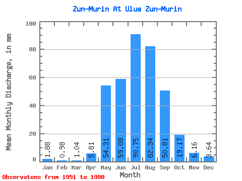
| Statistic | Jan | Feb | Mar | Apr | May | Jun | Jul | Aug | Sep | Oct | Nov | Dec | Annual |
|---|---|---|---|---|---|---|---|---|---|---|---|---|---|
| Mean | 1.88 | 0.99 | 1.04 | 5.81 | 54.30 | 59.08 | 90.73 | 82.32 | 50.81 | 19.17 | 6.16 | 3.64 | 372.59 |
| Standard Deviation | 1.07 | 0.70 | 0.64 | 4.13 | 21.61 | 23.64 | 38.62 | 25.70 | 20.42 | 4.94 | 2.32 | 1.72 | 74.12 |
| Min | 0.54 | 0.10 | 0.12 | 0.95 | 18.48 | 25.17 | 41.14 | 40.04 | 21.56 | 10.69 | 2.49 | 0.79 | 241.15 |
| Max | 4.94 | 2.78 | 2.34 | 18.07 | 110.72 | 119.01 | 189.91 | 151.93 | 130.85 | 31.67 | 11.65 | 9.14 | 595.20 |
| Coefficient of Variation | 0.57 | 0.71 | 0.62 | 0.71 | 0.40 | 0.40 | 0.43 | 0.31 | 0.40 | 0.26 | 0.38 | 0.47 | 0.20 |
 Return to R-Arctic Net Home Page