|
|
|||||||||||||||||
| Point ID: 6532 | Downloads | Plots | Site Data | Code: 8379 |
|
|
|||||||||||||||||
| Download | |
|---|---|
| Site Descriptor Information | Site Time Series Data |
| Link to all available data | |
| View: | Time Series | All |
| Units: | mm |
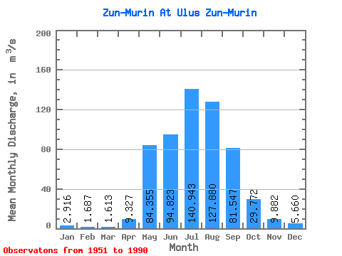
| Statistic | Jan | Feb | Mar | Apr | May | Jun | Jul | Aug | Sep | Oct | Nov | Dec | Annual |
|---|---|---|---|---|---|---|---|---|---|---|---|---|---|
| Mean | 2.92 | 1.69 | 1.61 | 9.33 | 84.36 | 94.82 | 140.94 | 127.88 | 81.55 | 29.77 | 9.88 | 5.66 | 49.11 |
| Standard Deviation | 1.66 | 1.19 | 1.00 | 6.62 | 33.56 | 37.95 | 59.99 | 39.92 | 32.78 | 7.67 | 3.72 | 2.67 | 9.77 |
| Min | 0.84 | 0.17 | 0.18 | 1.53 | 28.70 | 40.40 | 63.90 | 62.20 | 34.60 | 16.60 | 3.99 | 1.22 | 31.79 |
| Max | 7.68 | 4.74 | 3.63 | 29.00 | 172.00 | 191.00 | 295.00 | 236.00 | 210.00 | 49.20 | 18.70 | 14.20 | 78.45 |
| Coefficient of Variation | 0.57 | 0.71 | 0.62 | 0.71 | 0.40 | 0.40 | 0.43 | 0.31 | 0.40 | 0.26 | 0.38 | 0.47 | 0.20 |
 Return to R-Arctic Net Home Page