|
|
|||||||||||||||||
| Point ID: 6528 | Downloads | Plots | Site Data | Code: 8371 |
|
|
|||||||||||||||||
| Download | |
|---|---|
| Site Descriptor Information | Site Time Series Data |
| Link to all available data | |
| View: | Time Series | All |
| Units: | m3/s |
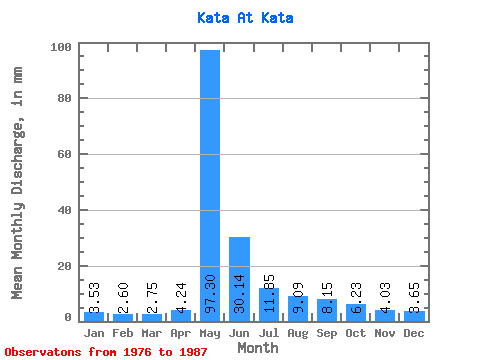
| Statistic | Jan | Feb | Mar | Apr | May | Jun | Jul | Aug | Sep | Oct | Nov | Dec | Annual |
|---|---|---|---|---|---|---|---|---|---|---|---|---|---|
| Mean | 3.53 | 2.62 | 2.75 | 4.24 | 97.29 | 30.14 | 11.85 | 9.09 | 8.15 | 6.23 | 4.03 | 3.65 | 182.93 |
| Standard Deviation | 1.46 | 0.91 | 0.85 | 2.38 | 22.17 | 27.57 | 6.22 | 3.78 | 3.22 | 2.97 | 1.93 | 1.81 | 51.16 |
| Min | 1.77 | 1.59 | 1.81 | 2.29 | 61.98 | 8.51 | 6.40 | 5.93 | 5.15 | 0.00 | 0.00 | 0.00 | 115.63 |
| Max | 6.70 | 4.24 | 4.41 | 9.94 | 135.75 | 114.11 | 24.93 | 16.17 | 15.00 | 11.59 | 7.34 | 7.21 | 291.32 |
| Coefficient of Variation | 0.41 | 0.35 | 0.31 | 0.56 | 0.23 | 0.92 | 0.53 | 0.42 | 0.40 | 0.48 | 0.48 | 0.49 | 0.28 |
 Return to R-Arctic Net Home Page