|
|
|||||||||||||||||
| Point ID: 6528 | Downloads | Plots | Site Data | Code: 8371 |
|
|
|||||||||||||||||
| Download | |
|---|---|
| Site Descriptor Information | Site Time Series Data |
| Link to all available data | |
| View: | Time Series | All |
| Units: | mm |
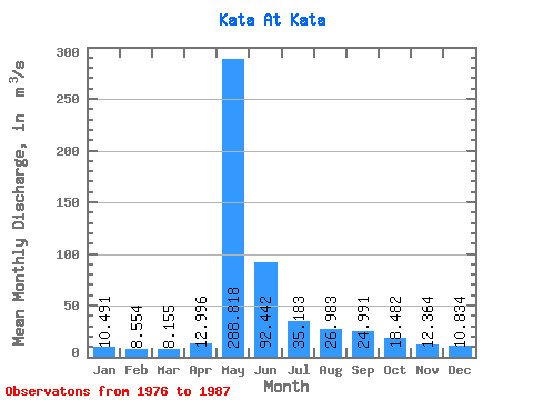
| Statistic | Jan | Feb | Mar | Apr | May | Jun | Jul | Aug | Sep | Oct | Nov | Dec | Annual |
|---|---|---|---|---|---|---|---|---|---|---|---|---|---|
| Mean | 10.49 | 8.55 | 8.15 | 13.00 | 288.82 | 92.44 | 35.18 | 26.98 | 24.99 | 18.48 | 12.36 | 10.83 | 46.08 |
| Standard Deviation | 4.32 | 2.98 | 2.52 | 7.29 | 65.82 | 84.56 | 18.46 | 11.23 | 9.88 | 8.82 | 5.90 | 5.36 | 12.89 |
| Min | 5.26 | 5.19 | 5.36 | 7.02 | 184.00 | 26.10 | 19.00 | 17.60 | 15.80 | 0.00 | 0.00 | 0.00 | 29.13 |
| Max | 19.90 | 13.80 | 13.10 | 30.50 | 403.00 | 350.00 | 74.00 | 48.00 | 46.00 | 34.40 | 22.50 | 21.40 | 73.38 |
| Coefficient of Variation | 0.41 | 0.35 | 0.31 | 0.56 | 0.23 | 0.92 | 0.53 | 0.42 | 0.40 | 0.48 | 0.48 | 0.49 | 0.28 |
 Return to R-Arctic Net Home Page