|
|
|||||||||||||||||
| Point ID: 6495 | Downloads | Plots | Site Data | Code: 8288 |
|
|
|||||||||||||||||
| Download | |
|---|---|
| Site Descriptor Information | Site Time Series Data |
| Link to all available data | |
| View: | Time Series | All |
| Units: | m3/s |
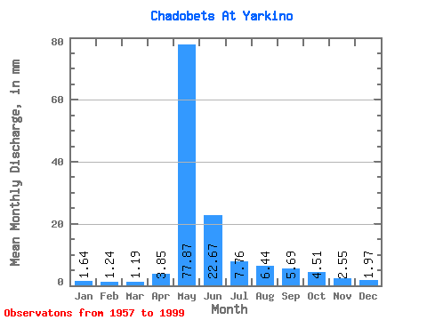
| Statistic | Jan | Feb | Mar | Apr | May | Jun | Jul | Aug | Sep | Oct | Nov | Dec | Annual |
|---|---|---|---|---|---|---|---|---|---|---|---|---|---|
| Mean | 1.64 | 1.25 | 1.19 | 3.85 | 77.86 | 22.67 | 7.76 | 6.44 | 5.69 | 4.51 | 2.55 | 1.97 | 136.17 |
| Standard Deviation | 0.83 | 0.59 | 0.58 | 9.31 | 21.74 | 13.98 | 3.58 | 5.22 | 2.44 | 2.06 | 1.36 | 0.92 | 36.13 |
| Min | 0.61 | 0.41 | 0.30 | 0.39 | 33.63 | 6.53 | 3.44 | 2.96 | 2.50 | 1.70 | 0.94 | 0.65 | 64.24 |
| Max | 5.34 | 3.19 | 2.86 | 58.86 | 126.25 | 82.24 | 18.26 | 31.41 | 13.00 | 10.21 | 8.13 | 6.02 | 264.44 |
| Coefficient of Variation | 0.51 | 0.47 | 0.49 | 2.42 | 0.28 | 0.62 | 0.46 | 0.81 | 0.43 | 0.46 | 0.53 | 0.47 | 0.27 |
 Return to R-Arctic Net Home Page