|
|
|||||||||||||||||
| Point ID: 6495 | Downloads | Plots | Site Data | Code: 8288 |
|
|
|||||||||||||||||
| Download | |
|---|---|
| Site Descriptor Information | Site Time Series Data |
| Link to all available data | |
| View: | Time Series | All |
| Units: | mm |
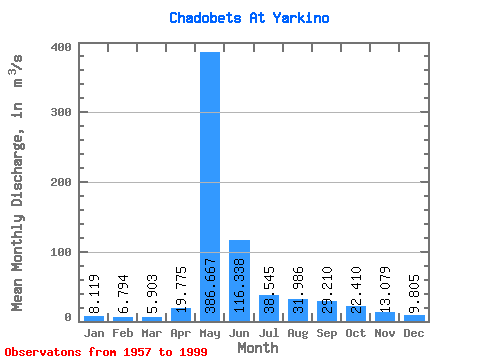
| Statistic | Jan | Feb | Mar | Apr | May | Jun | Jul | Aug | Sep | Oct | Nov | Dec | Annual |
|---|---|---|---|---|---|---|---|---|---|---|---|---|---|
| Mean | 8.12 | 6.79 | 5.90 | 19.77 | 386.67 | 116.34 | 38.55 | 31.99 | 29.21 | 22.41 | 13.08 | 9.80 | 57.39 |
| Standard Deviation | 4.13 | 3.19 | 2.88 | 47.78 | 107.96 | 71.72 | 17.76 | 25.92 | 12.50 | 10.21 | 6.96 | 4.56 | 15.23 |
| Min | 3.03 | 2.24 | 1.51 | 2.01 | 167.00 | 33.50 | 17.10 | 14.70 | 12.80 | 8.45 | 4.84 | 3.25 | 27.07 |
| Max | 26.50 | 17.40 | 14.20 | 302.00 | 627.00 | 422.00 | 90.70 | 156.00 | 66.70 | 50.70 | 41.70 | 29.90 | 111.44 |
| Coefficient of Variation | 0.51 | 0.47 | 0.49 | 2.42 | 0.28 | 0.62 | 0.46 | 0.81 | 0.43 | 0.46 | 0.53 | 0.47 | 0.27 |
 Return to R-Arctic Net Home Page