|
|
|||||||||||||||||
| Point ID: 6449 | Downloads | Plots | Site Data | Code: 7168 |
|
|
|||||||||||||||||
| Download | |
|---|---|
| Site Descriptor Information | Site Time Series Data |
| Link to all available data | |
| View: | Time Series | All |
| Units: | m3/s |
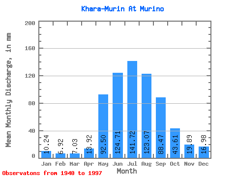
| Statistic | Jan | Feb | Mar | Apr | May | Jun | Jul | Aug | Sep | Oct | Nov | Dec | Annual |
|---|---|---|---|---|---|---|---|---|---|---|---|---|---|
| Mean | 10.24 | 6.98 | 7.03 | 13.92 | 92.48 | 124.70 | 141.70 | 123.05 | 88.47 | 43.61 | 19.89 | 16.98 | 685.41 |
| Standard Deviation | 2.15 | 2.00 | 3.64 | 7.22 | 24.14 | 52.90 | 78.38 | 51.20 | 35.39 | 9.60 | 4.19 | 19.92 | 142.89 |
| Min | 4.67 | 1.90 | 1.42 | 5.74 | 36.50 | 50.23 | 57.83 | 47.16 | 39.45 | 25.12 | 2.50 | 9.55 | 430.64 |
| Max | 14.86 | 12.16 | 22.61 | 43.35 | 149.54 | 291.31 | 421.84 | 251.21 | 218.14 | 68.73 | 28.67 | 165.18 | 1056.21 |
| Coefficient of Variation | 0.21 | 0.29 | 0.52 | 0.52 | 0.26 | 0.42 | 0.55 | 0.42 | 0.40 | 0.22 | 0.21 | 1.17 | 0.21 |
 Return to R-Arctic Net Home Page