|
|
|||||||||||||||||
| Point ID: 6449 | Downloads | Plots | Site Data | Code: 7168 |
|
|
|||||||||||||||||
| Download | |
|---|---|
| Site Descriptor Information | Site Time Series Data |
| Link to all available data | |
| View: | Time Series | All |
| Units: | mm |
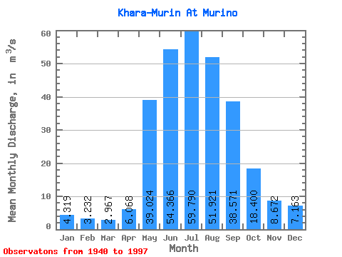
| Statistic | Jan | Feb | Mar | Apr | May | Jun | Jul | Aug | Sep | Oct | Nov | Dec | Annual |
|---|---|---|---|---|---|---|---|---|---|---|---|---|---|
| Mean | 4.32 | 3.23 | 2.97 | 6.07 | 39.02 | 54.37 | 59.79 | 51.92 | 38.57 | 18.40 | 8.67 | 7.16 | 24.54 |
| Standard Deviation | 0.91 | 0.93 | 1.54 | 3.15 | 10.19 | 23.06 | 33.08 | 21.61 | 15.43 | 4.05 | 1.83 | 8.41 | 5.12 |
| Min | 1.97 | 0.88 | 0.60 | 2.50 | 15.40 | 21.90 | 24.40 | 19.90 | 17.20 | 10.60 | 1.09 | 4.03 | 15.42 |
| Max | 6.27 | 5.63 | 9.54 | 18.90 | 63.10 | 127.00 | 178.00 | 106.00 | 95.10 | 29.00 | 12.50 | 69.70 | 37.82 |
| Coefficient of Variation | 0.21 | 0.29 | 0.52 | 0.52 | 0.26 | 0.42 | 0.55 | 0.42 | 0.40 | 0.22 | 0.21 | 1.17 | 0.21 |
 Return to R-Arctic Net Home Page