|
|
|||||||||||||||||
| Point ID: 6439 | Downloads | Plots | Site Data | Other Close Sites | Code: 7130 |
|
|
|||||||||||||||||
| Download | |
|---|---|
| Site Descriptor Information | Site Time Series Data |
| Link to all available data | |
| View: | Time Series | All |
| Units: | m3/s |
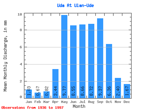
| Statistic | Jan | Feb | Mar | Apr | May | Jun | Jul | Aug | Sep | Oct | Nov | Dec | Annual |
|---|---|---|---|---|---|---|---|---|---|---|---|---|---|
| Mean | 1.03 | 0.68 | 0.82 | 3.44 | 9.77 | 8.55 | 8.66 | 8.72 | 9.37 | 6.36 | 2.40 | 1.67 | 61.19 |
| Standard Deviation | 0.48 | 0.32 | 0.36 | 1.86 | 4.00 | 6.10 | 5.83 | 4.44 | 7.02 | 3.01 | 0.86 | 0.76 | 22.86 |
| Min | 0.22 | 0.18 | 0.23 | 0.88 | 3.80 | 3.17 | 2.44 | 2.42 | 2.26 | 2.04 | 1.15 | 0.67 | 27.13 |
| Max | 2.38 | 1.74 | 1.72 | 13.15 | 24.08 | 36.08 | 34.88 | 21.53 | 43.85 | 17.98 | 4.38 | 3.93 | 125.92 |
| Coefficient of Variation | 0.47 | 0.47 | 0.44 | 0.54 | 0.41 | 0.71 | 0.67 | 0.51 | 0.75 | 0.47 | 0.36 | 0.46 | 0.37 |
| Other Close Sites | ||||||
|---|---|---|---|---|---|---|
| PointID | Latitude | Longitude | Drainage Area | Source | Name | |
| 6412 | "Selenga At Raz'ezd Mostovoy" | 52.03 | 1245161 | SHI | 127.00 | |
 Return to R-Arctic Net Home Page