|
|
|||||||||||||||||
| Point ID: 6412 | Downloads | Plots | Site Data | Other Close Sites | Code: 7051 |
|
|
|||||||||||||||||
| Download | |
|---|---|
| Site Descriptor Information | Site Time Series Data |
| Link to all available data | |
| View: | Time Series | All |
| Units: | m3/s |
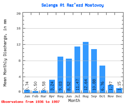
| Statistic | Jan | Feb | Mar | Apr | May | Jun | Jul | Aug | Sep | Oct | Nov | Dec | Annual |
|---|---|---|---|---|---|---|---|---|---|---|---|---|---|
| Mean | 0.74 | 0.50 | 0.58 | 3.24 | 9.03 | 8.52 | 11.47 | 12.64 | 10.88 | 6.76 | 1.97 | 1.15 | 67.12 |
| Standard Deviation | 0.26 | 0.20 | 0.25 | 1.25 | 2.94 | 3.18 | 4.07 | 4.82 | 4.08 | 1.82 | 0.53 | 0.31 | 15.23 |
| Min | 0.29 | 0.19 | 0.23 | 0.75 | 4.51 | 3.58 | 4.60 | 5.33 | 4.23 | 3.31 | 1.06 | 0.69 | 36.94 |
| Max | 1.39 | 1.25 | 1.70 | 6.07 | 19.17 | 22.56 | 22.03 | 26.54 | 20.80 | 11.69 | 3.53 | 1.92 | 105.59 |
| Coefficient of Variation | 0.35 | 0.40 | 0.43 | 0.39 | 0.33 | 0.37 | 0.35 | 0.38 | 0.38 | 0.27 | 0.27 | 0.27 | 0.23 |
| Other Close Sites | ||||||
|---|---|---|---|---|---|---|
| PointID | Latitude | Longitude | Drainage Area | Source | Name | |
| 6439 | "Uda At Ulan-Ude" | 51.83 | 1261875 | SHI | 5.10 | |
 Return to R-Arctic Net Home Page