|
|
|||||||||||||||||
| Point ID: 6435 | Downloads | Plots | Site Data | Code: 7118 |
|
|
|||||||||||||||||
| Download | |
|---|---|
| Site Descriptor Information | Site Time Series Data |
| Link to all available data | |
| View: | Time Series | All |
| Units: | m3/s |
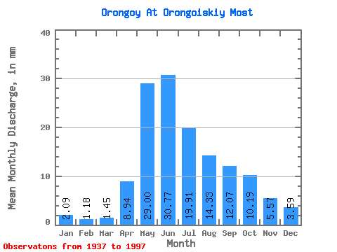
| Statistic | Jan | Feb | Mar | Apr | May | Jun | Jul | Aug | Sep | Oct | Nov | Dec | Annual |
|---|---|---|---|---|---|---|---|---|---|---|---|---|---|
| Mean | 2.09 | 1.19 | 1.45 | 8.94 | 28.99 | 30.77 | 19.91 | 14.32 | 12.07 | 10.19 | 5.57 | 3.59 | 141.54 |
| Standard Deviation | 1.12 | 0.79 | 1.12 | 3.69 | 11.48 | 15.87 | 13.06 | 7.60 | 5.76 | 4.69 | 2.64 | 1.77 | 45.10 |
| Min | 0.12 | 0.04 | 0.08 | 2.99 | 11.82 | 3.75 | 2.84 | 3.62 | 3.85 | 4.16 | 1.90 | 1.31 | 50.83 |
| Max | 4.66 | 3.58 | 4.91 | 19.44 | 60.40 | 73.53 | 60.55 | 39.73 | 28.03 | 27.65 | 13.30 | 8.56 | 233.27 |
| Coefficient of Variation | 0.54 | 0.67 | 0.77 | 0.41 | 0.40 | 0.52 | 0.66 | 0.53 | 0.48 | 0.46 | 0.47 | 0.49 | 0.32 |
 Return to R-Arctic Net Home Page