|
|
|||||||||||||||||
| Point ID: 6435 | Downloads | Plots | Site Data | Code: 7118 |
|
|
|||||||||||||||||
| Download | |
|---|---|
| Site Descriptor Information | Site Time Series Data |
| Link to all available data | |
| View: | Time Series | All |
| Units: | mm |
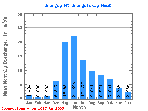
| Statistic | Jan | Feb | Mar | Apr | May | Jun | Jul | Aug | Sep | Oct | Nov | Dec | Annual |
|---|---|---|---|---|---|---|---|---|---|---|---|---|---|
| Mean | 1.43 | 0.90 | 0.99 | 6.35 | 19.92 | 21.85 | 13.68 | 9.84 | 8.57 | 7.00 | 3.96 | 2.47 | 8.25 |
| Standard Deviation | 0.77 | 0.60 | 0.77 | 2.62 | 7.89 | 11.27 | 8.97 | 5.22 | 4.09 | 3.22 | 1.88 | 1.22 | 2.63 |
| Min | 0.08 | 0.03 | 0.05 | 2.12 | 8.12 | 2.66 | 1.95 | 2.49 | 2.73 | 2.86 | 1.35 | 0.90 | 2.96 |
| Max | 3.20 | 2.70 | 3.37 | 13.80 | 41.50 | 52.20 | 41.60 | 27.30 | 19.90 | 19.00 | 9.44 | 5.88 | 13.60 |
| Coefficient of Variation | 0.54 | 0.67 | 0.77 | 0.41 | 0.40 | 0.52 | 0.66 | 0.53 | 0.48 | 0.46 | 0.47 | 0.49 | 0.32 |
 Return to R-Arctic Net Home Page