|
|
|||||||||||||||||
| Point ID: 6431 | Downloads | Plots | Site Data | Code: 7104 |
|
|
|||||||||||||||||
| Download | |
|---|---|
| Site Descriptor Information | Site Time Series Data |
| Link to all available data | |
| View: | Time Series | All |
| Units: | m3/s |
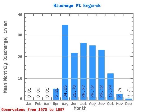
| Statistic | Jan | Feb | Mar | Apr | May | Jun | Jul | Aug | Sep | Oct | Nov | Dec | Annual |
|---|---|---|---|---|---|---|---|---|---|---|---|---|---|
| Mean | 0.01 | 0.00 | 0.01 | 5.26 | 34.65 | 21.79 | 26.36 | 25.11 | 23.12 | 12.29 | 2.79 | 0.71 | 151.07 |
| Standard Deviation | 0.03 | 0.00 | 0.07 | 5.25 | 21.47 | 14.78 | 16.81 | 16.99 | 16.60 | 8.09 | 1.65 | 0.58 | 59.25 |
| Min | 0.00 | 0.00 | 0.00 | 0.09 | 9.54 | 2.75 | 6.04 | 5.19 | 6.06 | 3.17 | 0.56 | 0.06 | 72.19 |
| Max | 0.14 | 0.00 | 0.33 | 20.93 | 97.85 | 62.21 | 67.16 | 62.62 | 72.97 | 40.17 | 7.06 | 2.43 | 267.22 |
| Coefficient of Variation | 2.44 | 4.90 | 1.00 | 0.62 | 0.68 | 0.64 | 0.68 | 0.72 | 0.66 | 0.59 | 0.81 | 0.39 |
 Return to R-Arctic Net Home Page