|
|
|||||||||||||||||
| Point ID: 6431 | Downloads | Plots | Site Data | Code: 7104 |
|
|
|||||||||||||||||
| Download | |
|---|---|
| Site Descriptor Information | Site Time Series Data |
| Link to all available data | |
| View: | Time Series | All |
| Units: | mm |
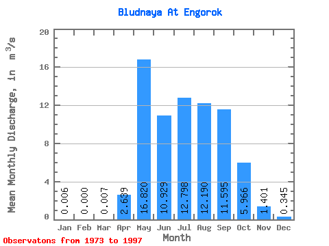
| Statistic | Jan | Feb | Mar | Apr | May | Jun | Jul | Aug | Sep | Oct | Nov | Dec | Annual |
|---|---|---|---|---|---|---|---|---|---|---|---|---|---|
| Mean | 0.01 | 0.00 | 0.01 | 2.64 | 16.82 | 10.93 | 12.80 | 12.19 | 11.60 | 5.97 | 1.40 | 0.34 | 6.22 |
| Standard Deviation | 0.01 | 0.00 | 0.03 | 2.63 | 10.42 | 7.41 | 8.16 | 8.25 | 8.32 | 3.93 | 0.83 | 0.28 | 2.44 |
| Min | 0.00 | 0.00 | 0.00 | 0.05 | 4.63 | 1.38 | 2.93 | 2.52 | 3.04 | 1.54 | 0.28 | 0.03 | 2.97 |
| Max | 0.07 | 0.00 | 0.16 | 10.50 | 47.50 | 31.20 | 32.60 | 30.40 | 36.60 | 19.50 | 3.54 | 1.18 | 11.01 |
| Coefficient of Variation | 2.44 | 4.90 | 1.00 | 0.62 | 0.68 | 0.64 | 0.68 | 0.72 | 0.66 | 0.59 | 0.81 | 0.39 |
 Return to R-Arctic Net Home Page