|
|
|||||||||||||||||
| Point ID: 6416 | Downloads | Plots | Site Data | Code: 7062 |
|
|
|||||||||||||||||
| Download | |
|---|---|
| Site Descriptor Information | Site Time Series Data |
| Link to all available data | |
| View: | Time Series | All |
| Units: | m3/s |
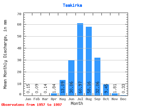
| Statistic | Jan | Feb | Mar | Apr | May | Jun | Jul | Aug | Sep | Oct | Nov | Dec | Annual |
|---|---|---|---|---|---|---|---|---|---|---|---|---|---|
| Mean | 0.15 | 0.09 | 0.14 | 1.84 | 13.09 | 30.06 | 60.96 | 58.15 | 32.06 | 9.45 | 1.81 | 0.33 | 209.68 |
| Standard Deviation | 0.12 | 0.11 | 0.26 | 1.24 | 9.87 | 17.36 | 37.43 | 34.67 | 26.70 | 6.57 | 1.75 | 0.20 | 94.49 |
| Min | 0.00 | 0.00 | 0.00 | 0.13 | 1.74 | 4.23 | 13.00 | 14.43 | 5.08 | 3.56 | 0.63 | 0.12 | 57.32 |
| Max | 0.68 | 0.62 | 1.64 | 5.54 | 64.22 | 82.79 | 161.20 | 172.64 | 124.06 | 37.96 | 11.98 | 1.27 | 566.58 |
| Coefficient of Variation | 0.81 | 1.25 | 1.89 | 0.67 | 0.75 | 0.58 | 0.61 | 0.60 | 0.83 | 0.69 | 0.97 | 0.58 | 0.45 |
 Return to R-Arctic Net Home Page