|
|
|||||||||||||||||
| Point ID: 6416 | Downloads | Plots | Site Data | Code: 7062 |
|
|
|||||||||||||||||
| Download | |
|---|---|
| Site Descriptor Information | Site Time Series Data |
| Link to all available data | |
| View: | Time Series | All |
| Units: | mm |
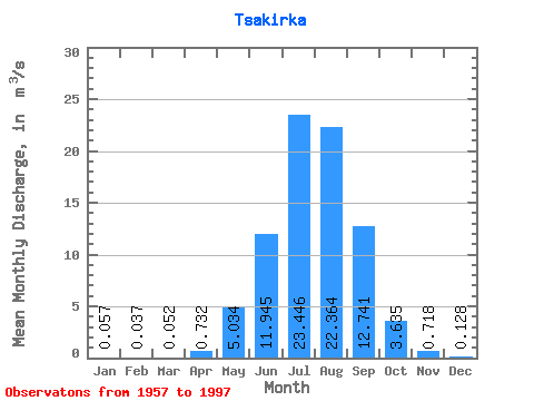
| Statistic | Jan | Feb | Mar | Apr | May | Jun | Jul | Aug | Sep | Oct | Nov | Dec | Annual |
|---|---|---|---|---|---|---|---|---|---|---|---|---|---|
| Mean | 0.06 | 0.04 | 0.05 | 0.73 | 5.03 | 11.95 | 23.45 | 22.36 | 12.74 | 3.63 | 0.72 | 0.13 | 6.84 |
| Standard Deviation | 0.05 | 0.05 | 0.10 | 0.49 | 3.79 | 6.90 | 14.40 | 13.34 | 10.61 | 2.52 | 0.70 | 0.07 | 3.08 |
| Min | 0.00 | 0.00 | 0.00 | 0.05 | 0.67 | 1.68 | 5.00 | 5.55 | 2.02 | 1.37 | 0.25 | 0.04 | 1.87 |
| Max | 0.26 | 0.26 | 0.63 | 2.20 | 24.70 | 32.90 | 62.00 | 66.40 | 49.30 | 14.60 | 4.76 | 0.49 | 18.49 |
| Coefficient of Variation | 0.81 | 1.25 | 1.89 | 0.67 | 0.75 | 0.58 | 0.61 | 0.60 | 0.83 | 0.69 | 0.97 | 0.58 | 0.45 |
 Return to R-Arctic Net Home Page