|
|
|||||||||||||||||
| Point ID: 6408 | Downloads | Plots | Site Data | Code: 7036 |
|
|
|||||||||||||||||
| Download | |
|---|---|
| Site Descriptor Information | Site Time Series Data |
| Link to all available data | |
| View: | Time Series | All |
| Units: | m3/s |
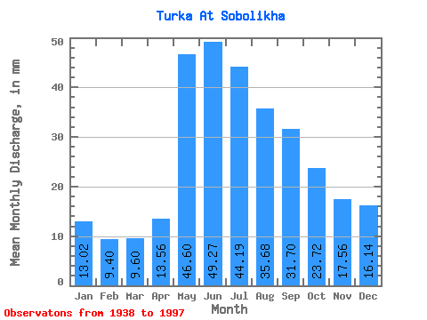
| Statistic | Jan | Feb | Mar | Apr | May | Jun | Jul | Aug | Sep | Oct | Nov | Dec | Annual |
|---|---|---|---|---|---|---|---|---|---|---|---|---|---|
| Mean | 13.02 | 9.48 | 9.59 | 13.56 | 46.60 | 49.27 | 44.19 | 35.68 | 31.70 | 23.71 | 17.56 | 16.14 | 309.71 |
| Standard Deviation | 6.55 | 5.48 | 6.05 | 7.43 | 13.38 | 20.96 | 27.99 | 15.89 | 17.16 | 10.07 | 9.04 | 7.39 | 99.78 |
| Min | 5.94 | 4.65 | 4.67 | 4.83 | 24.66 | 15.50 | 11.83 | 11.56 | 10.37 | 10.61 | 5.80 | 7.74 | 154.47 |
| Max | 29.54 | 24.21 | 27.95 | 30.08 | 80.61 | 142.69 | 190.38 | 89.09 | 111.89 | 60.98 | 41.58 | 35.27 | 668.33 |
| Coefficient of Variation | 0.50 | 0.58 | 0.63 | 0.55 | 0.29 | 0.42 | 0.63 | 0.45 | 0.54 | 0.42 | 0.52 | 0.46 | 0.32 |
 Return to R-Arctic Net Home Page