|
|
|||||||||||||||||
| Point ID: 6408 | Downloads | Plots | Site Data | Code: 7036 |
|
|
|||||||||||||||||
| Download | |
|---|---|
| Site Descriptor Information | Site Time Series Data |
| Link to all available data | |
| View: | Time Series | All |
| Units: | mm |
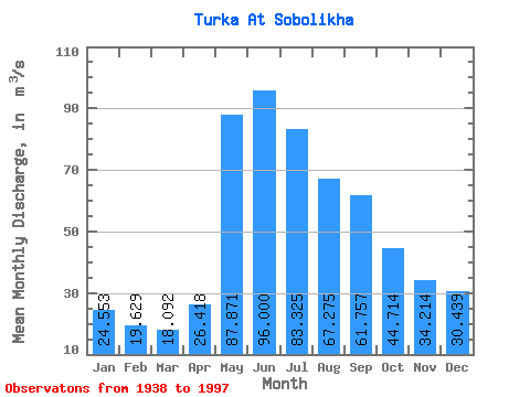
| Statistic | Jan | Feb | Mar | Apr | May | Jun | Jul | Aug | Sep | Oct | Nov | Dec | Annual |
|---|---|---|---|---|---|---|---|---|---|---|---|---|---|
| Mean | 24.55 | 19.63 | 18.09 | 26.42 | 87.87 | 96.00 | 83.33 | 67.28 | 61.76 | 44.71 | 34.21 | 30.44 | 49.56 |
| Standard Deviation | 12.35 | 11.35 | 11.41 | 14.48 | 25.23 | 40.84 | 52.77 | 29.96 | 33.43 | 19.00 | 17.62 | 13.93 | 15.97 |
| Min | 11.20 | 9.63 | 8.81 | 9.41 | 46.50 | 30.20 | 22.30 | 21.80 | 20.20 | 20.00 | 11.30 | 14.60 | 24.72 |
| Max | 55.70 | 50.10 | 52.70 | 58.60 | 152.00 | 278.00 | 359.00 | 168.00 | 218.00 | 115.00 | 81.00 | 66.50 | 106.94 |
| Coefficient of Variation | 0.50 | 0.58 | 0.63 | 0.55 | 0.29 | 0.42 | 0.63 | 0.45 | 0.54 | 0.42 | 0.52 | 0.46 | 0.32 |
 Return to R-Arctic Net Home Page