|
|
|||||||||||||||||
| Point ID: 6402 | Downloads | Plots | Site Data | Code: 7015 |
|
|
|||||||||||||||||
| Download | |
|---|---|
| Site Descriptor Information | Site Time Series Data |
| Link to all available data | |
| View: | Time Series | All |
| Units: | m3/s |
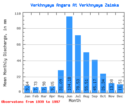
| Statistic | Jan | Feb | Mar | Apr | May | Jun | Jul | Aug | Sep | Oct | Nov | Dec | Annual |
|---|---|---|---|---|---|---|---|---|---|---|---|---|---|
| Mean | 9.64 | 7.80 | 7.98 | 9.05 | 31.08 | 104.18 | 78.52 | 55.50 | 45.17 | 26.34 | 13.08 | 11.51 | 399.02 |
| Standard Deviation | 1.09 | 0.91 | 0.89 | 1.56 | 14.04 | 22.24 | 27.75 | 16.78 | 14.40 | 6.39 | 2.16 | 1.67 | 58.48 |
| Min | 6.92 | 5.54 | 6.25 | 5.90 | 2.29 | 50.71 | 27.95 | 24.96 | 22.27 | 15.99 | 9.42 | 8.06 | 282.87 |
| Max | 12.96 | 10.35 | 10.21 | 13.46 | 108.16 | 158.54 | 140.40 | 97.63 | 99.53 | 42.38 | 18.75 | 16.25 | 557.05 |
| Coefficient of Variation | 0.11 | 0.12 | 0.11 | 0.17 | 0.45 | 0.21 | 0.35 | 0.30 | 0.32 | 0.24 | 0.17 | 0.14 | 0.15 |
 Return to R-Arctic Net Home Page