|
|
|||||||||||||||||
| Point ID: 6402 | Downloads | Plots | Site Data | Code: 7015 |
|
|
|||||||||||||||||
| Download | |
|---|---|
| Site Descriptor Information | Site Time Series Data |
| Link to all available data | |
| View: | Time Series | All |
| Units: | mm |
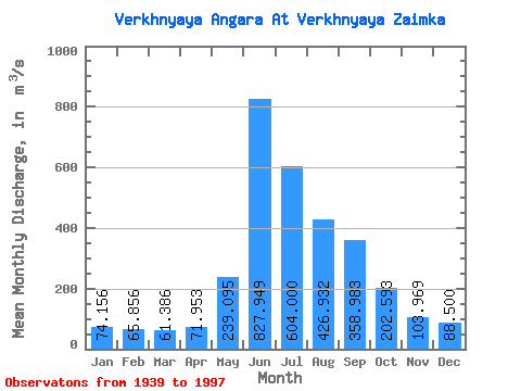
| Statistic | Jan | Feb | Mar | Apr | May | Jun | Jul | Aug | Sep | Oct | Nov | Dec | Annual |
|---|---|---|---|---|---|---|---|---|---|---|---|---|---|
| Mean | 74.16 | 65.86 | 61.39 | 71.95 | 239.09 | 827.95 | 604.00 | 426.93 | 358.98 | 202.59 | 103.97 | 88.50 | 260.45 |
| Standard Deviation | 8.36 | 7.66 | 6.87 | 12.39 | 107.98 | 176.73 | 213.48 | 129.06 | 114.42 | 49.19 | 17.14 | 12.81 | 38.17 |
| Min | 53.20 | 46.80 | 48.10 | 46.90 | 17.60 | 403.00 | 215.00 | 192.00 | 177.00 | 123.00 | 74.90 | 62.00 | 184.63 |
| Max | 99.70 | 87.40 | 78.50 | 107.00 | 832.00 | 1260.00 | 1080.00 | 751.00 | 791.00 | 326.00 | 149.00 | 125.00 | 363.60 |
| Coefficient of Variation | 0.11 | 0.12 | 0.11 | 0.17 | 0.45 | 0.21 | 0.35 | 0.30 | 0.32 | 0.24 | 0.17 | 0.14 | 0.15 |
 Return to R-Arctic Net Home Page