|
|
|||||||||||||||||
| Point ID: 6401 | Downloads | Plots | Site Data | Code: 7012 |
|
|
|||||||||||||||||
| Download | |
|---|---|
| Site Descriptor Information | Site Time Series Data |
| Link to all available data | |
| View: | Time Series | All |
| Units: | m3/s |
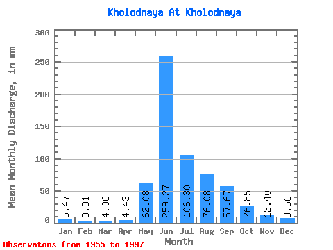
| Statistic | Jan | Feb | Mar | Apr | May | Jun | Jul | Aug | Sep | Oct | Nov | Dec | Annual |
|---|---|---|---|---|---|---|---|---|---|---|---|---|---|
| Mean | 5.47 | 3.85 | 4.06 | 4.43 | 62.07 | 259.27 | 106.28 | 76.07 | 57.67 | 26.85 | 12.40 | 8.56 | 629.71 |
| Standard Deviation | 1.33 | 0.84 | 1.03 | 1.12 | 39.34 | 85.30 | 44.26 | 31.39 | 17.06 | 7.10 | 3.55 | 1.52 | 123.43 |
| Min | 3.32 | 2.49 | 2.07 | 2.59 | 9.90 | 95.29 | 43.87 | 30.61 | 29.13 | 15.53 | 4.27 | 4.39 | 386.81 |
| Max | 8.57 | 5.69 | 7.50 | 7.80 | 168.33 | 439.41 | 249.69 | 160.17 | 100.47 | 45.91 | 20.09 | 10.99 | 882.20 |
| Coefficient of Variation | 0.24 | 0.22 | 0.26 | 0.25 | 0.63 | 0.33 | 0.42 | 0.41 | 0.30 | 0.26 | 0.29 | 0.18 | 0.20 |
 Return to R-Arctic Net Home Page