|
|
|||||||||||||||||
| Point ID: 6401 | Downloads | Plots | Site Data | Code: 7012 |
|
|
|||||||||||||||||
| Download | |
|---|---|
| Site Descriptor Information | Site Time Series Data |
| Link to all available data | |
| View: | Time Series | All |
| Units: | mm |
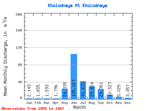
| Statistic | Jan | Feb | Mar | Apr | May | Jun | Jul | Aug | Sep | Oct | Nov | Dec | Annual |
|---|---|---|---|---|---|---|---|---|---|---|---|---|---|
| Mean | 2.14 | 1.66 | 1.59 | 1.80 | 24.34 | 105.03 | 41.67 | 29.82 | 23.36 | 10.53 | 5.03 | 3.36 | 20.95 |
| Standard Deviation | 0.52 | 0.36 | 0.41 | 0.45 | 15.42 | 34.55 | 17.35 | 12.31 | 6.91 | 2.78 | 1.44 | 0.59 | 4.11 |
| Min | 1.30 | 1.07 | 0.81 | 1.05 | 3.88 | 38.60 | 17.20 | 12.00 | 11.80 | 6.09 | 1.73 | 1.72 | 12.87 |
| Max | 3.36 | 2.45 | 2.94 | 3.16 | 66.00 | 178.00 | 97.90 | 62.80 | 40.70 | 18.00 | 8.14 | 4.31 | 29.35 |
| Coefficient of Variation | 0.24 | 0.22 | 0.26 | 0.25 | 0.63 | 0.33 | 0.42 | 0.41 | 0.30 | 0.26 | 0.29 | 0.18 | 0.20 |
 Return to R-Arctic Net Home Page