|
|
|||||||||||||||||
| Point ID: 636 | Downloads | Plots | Site Data | Code: 07AG007 |
|
|
|||||||||||||||||
| Download | |
|---|---|
| Site Descriptor Information | Site Time Series Data |
| Link to all available data | |
| View: | Time Series | All |
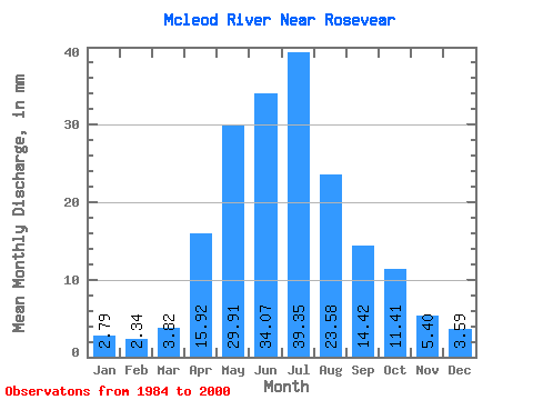
| Units: | m3/s |
| Statistic | Jan | Feb | Mar | Apr | May | Jun | Jul | Aug | Sep | Oct | Nov | Dec | Annual |
|---|---|---|---|---|---|---|---|---|---|---|---|---|---|
| Mean | 2.76 | 2.33 | 3.78 | 15.74 | 29.57 | 33.68 | 38.91 | 23.31 | 14.26 | 11.29 | 5.34 | 3.55 | 185.60 |
| Standard Deviation | 0.80 | 0.61 | 2.64 | 7.94 | 15.71 | 18.98 | 29.54 | 21.56 | 8.89 | 7.36 | 2.20 | 1.29 | 58.79 |
| Min | 1.77 | 1.45 | 1.76 | 7.65 | 8.35 | 8.77 | 7.34 | 3.66 | 5.80 | 4.34 | 2.58 | 1.48 | 87.97 |
| Max | 4.16 | 3.41 | 13.37 | 32.63 | 65.55 | 84.47 | 110.86 | 80.90 | 33.24 | 32.44 | 10.08 | 6.11 | 272.71 |
| Coefficient of Variation | 0.29 | 0.26 | 0.70 | 0.50 | 0.53 | 0.56 | 0.76 | 0.93 | 0.62 | 0.65 | 0.41 | 0.36 | 0.32 |
 Return to R-Arctic Net Home Page