|
|
|||||||||||||||||
| Point ID: 636 | Downloads | Plots | Site Data | Code: 07AG007 |
|
|
|||||||||||||||||
| Download | |
|---|---|
| Site Descriptor Information | Site Time Series Data |
| Link to all available data | |
| View: | Time Series | All |
| Units: | mm |
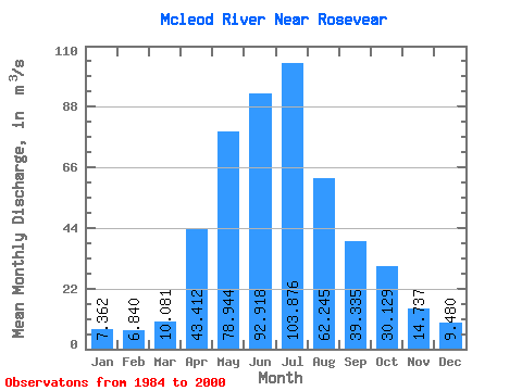
| Statistic | Jan | Feb | Mar | Apr | May | Jun | Jul | Aug | Sep | Oct | Nov | Dec | Annual |
|---|---|---|---|---|---|---|---|---|---|---|---|---|---|
| Mean | 7.36 | 6.84 | 10.08 | 43.41 | 78.94 | 92.92 | 103.88 | 62.24 | 39.34 | 30.13 | 14.74 | 9.48 | 42.05 |
| Standard Deviation | 2.12 | 1.79 | 7.05 | 21.90 | 41.94 | 52.35 | 78.86 | 57.56 | 24.51 | 19.66 | 6.06 | 3.44 | 13.32 |
| Min | 4.74 | 4.24 | 4.69 | 21.10 | 22.30 | 24.20 | 19.60 | 9.76 | 16.00 | 11.60 | 7.12 | 3.96 | 19.93 |
| Max | 11.10 | 10.00 | 35.70 | 90.00 | 175.00 | 233.00 | 296.00 | 216.00 | 91.70 | 86.60 | 27.80 | 16.30 | 61.78 |
| Coefficient of Variation | 0.29 | 0.26 | 0.70 | 0.50 | 0.53 | 0.56 | 0.76 | 0.93 | 0.62 | 0.65 | 0.41 | 0.36 | 0.32 |
 Return to R-Arctic Net Home Page