|
|
|||||||||||||||||
| Point ID: 6350 | Downloads | Plots | Site Data | Code: 3851 |
|
|
|||||||||||||||||
| Download | |
|---|---|
| Site Descriptor Information | Site Time Series Data |
| Link to all available data | |
| View: | Time Series | All |
| Units: | m3/s |
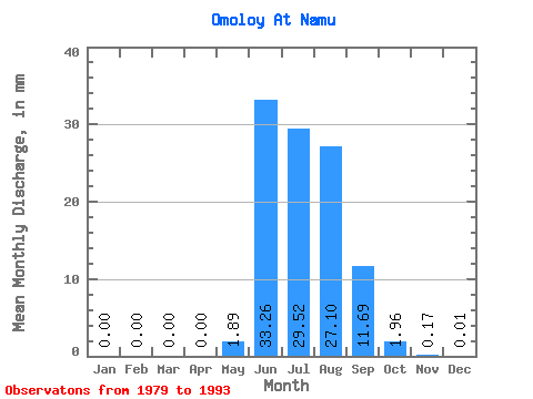
| Statistic | Jan | Feb | Mar | Apr | May | Jun | Jul | Aug | Sep | Oct | Nov | Dec | Annual |
|---|---|---|---|---|---|---|---|---|---|---|---|---|---|
| Mean | 0.00 | 0.00 | 0.00 | 0.00 | 1.89 | 33.26 | 29.52 | 27.09 | 11.69 | 1.96 | 0.17 | 0.01 | 105.17 |
| Standard Deviation | 0.00 | 0.00 | 0.00 | 0.00 | 3.32 | 18.68 | 12.52 | 12.60 | 4.88 | 1.48 | 0.29 | 0.02 | 34.03 |
| Min | 0.00 | 0.00 | 0.00 | 0.00 | 0.00 | 10.66 | 13.29 | 10.59 | 4.73 | 0.20 | 0.00 | 0.00 | 49.51 |
| Max | 0.00 | 0.00 | 0.00 | 0.00 | 10.39 | 82.32 | 61.00 | 52.32 | 19.25 | 4.36 | 1.12 | 0.09 | 167.60 |
| Coefficient of Variation | 0.00 | 0.00 | 0.00 | 0.00 | 1.76 | 0.56 | 0.42 | 0.47 | 0.42 | 0.75 | 1.76 | 3.71 | 0.32 |
 Return to R-Arctic Net Home Page