|
|
|||||||||||||||||
| Point ID: 6350 | Downloads | Plots | Site Data | Code: 3851 |
|
|
|||||||||||||||||
| Download | |
|---|---|
| Site Descriptor Information | Site Time Series Data |
| Link to all available data | |
| View: | Time Series | All |
| Units: | mm |
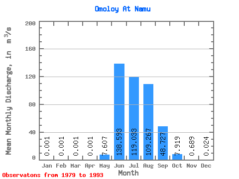
| Statistic | Jan | Feb | Mar | Apr | May | Jun | Jul | Aug | Sep | Oct | Nov | Dec | Annual |
|---|---|---|---|---|---|---|---|---|---|---|---|---|---|
| Mean | 0.00 | 0.00 | 0.00 | 0.00 | 7.61 | 138.59 | 119.03 | 109.27 | 48.73 | 7.92 | 0.69 | 0.02 | 35.99 |
| Standard Deviation | 0.00 | 0.00 | 0.00 | 0.00 | 13.39 | 77.82 | 50.48 | 50.83 | 20.31 | 5.97 | 1.21 | 0.09 | 11.64 |
| Min | 0.00 | 0.00 | 0.00 | 0.00 | 0.00 | 44.40 | 53.60 | 42.70 | 19.70 | 0.82 | 0.00 | 0.00 | 16.94 |
| Max | 0.00 | 0.00 | 0.00 | 0.00 | 41.90 | 343.00 | 246.00 | 211.00 | 80.20 | 17.60 | 4.66 | 0.35 | 57.35 |
| Coefficient of Variation | 0.00 | 0.00 | 0.00 | 0.00 | 1.76 | 0.56 | 0.42 | 0.47 | 0.42 | 0.75 | 1.76 | 3.71 | 0.32 |
 Return to R-Arctic Net Home Page