|
|
|||||||||||||||||
| Point ID: 633 | Downloads | Plots | Site Data | Code: 07AG004 |
|
|
|||||||||||||||||
| Download | |
|---|---|
| Site Descriptor Information | Site Time Series Data |
| Link to all available data | |
| View: | Time Series | All |
| Units: | m3/s |
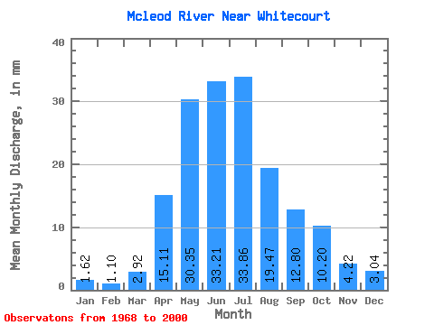
| Statistic | Jan | Feb | Mar | Apr | May | Jun | Jul | Aug | Sep | Oct | Nov | Dec | Annual |
|---|---|---|---|---|---|---|---|---|---|---|---|---|---|
| Mean | 1.60 | 1.09 | 2.88 | 14.93 | 29.98 | 32.80 | 33.45 | 19.24 | 12.65 | 10.08 | 4.17 | 3.01 | 175.45 |
| Standard Deviation | 0.46 | 0.68 | 1.71 | 7.41 | 16.04 | 24.36 | 24.18 | 16.67 | 8.97 | 6.78 | 1.11 | 0.28 | |
| Min | 1.28 | 0.62 | 0.83 | 5.64 | 7.62 | 7.66 | 6.45 | 3.15 | 4.16 | 3.09 | 3.39 | 2.81 | 175.45 |
| Max | 1.93 | 1.57 | 10.54 | 30.48 | 72.39 | 126.18 | 92.11 | 74.75 | 38.74 | 30.90 | 4.96 | 3.21 | 175.45 |
| Coefficient of Variation | 0.28 | 0.62 | 0.59 | 0.50 | 0.54 | 0.74 | 0.72 | 0.87 | 0.71 | 0.67 | 0.27 | 0.09 |
 Return to R-Arctic Net Home Page