|
|
|||||||||||||||||
| Point ID: 633 | Downloads | Plots | Site Data | Code: 07AG004 |
|
|
|||||||||||||||||
| Download | |
|---|---|
| Site Descriptor Information | Site Time Series Data |
| Link to all available data | |
| View: | Time Series | All |
| Units: | mm |
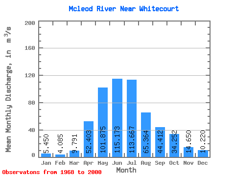
| Statistic | Jan | Feb | Mar | Apr | May | Jun | Jul | Aug | Sep | Oct | Nov | Dec | Annual |
|---|---|---|---|---|---|---|---|---|---|---|---|---|---|
| Mean | 5.45 | 4.08 | 9.79 | 52.40 | 101.88 | 115.17 | 113.67 | 65.36 | 44.41 | 34.25 | 14.65 | 10.22 | 50.59 |
| Standard Deviation | 1.56 | 2.52 | 5.80 | 26.01 | 54.49 | 85.54 | 82.18 | 56.66 | 31.50 | 23.04 | 3.89 | 0.96 | |
| Min | 4.35 | 2.30 | 2.83 | 19.80 | 25.90 | 26.90 | 21.90 | 10.70 | 14.60 | 10.50 | 11.90 | 9.54 | 50.59 |
| Max | 6.55 | 5.87 | 35.80 | 107.00 | 246.00 | 443.00 | 313.00 | 254.00 | 136.00 | 105.00 | 17.40 | 10.90 | 50.59 |
| Coefficient of Variation | 0.28 | 0.62 | 0.59 | 0.50 | 0.54 | 0.74 | 0.72 | 0.87 | 0.71 | 0.67 | 0.27 | 0.09 |
 Return to R-Arctic Net Home Page