|
|
|||||||||||||||||
| Point ID: 6311 | Downloads | Plots | Site Data | Code: 3536 |
|
|
|||||||||||||||||
| Download | |
|---|---|
| Site Descriptor Information | Site Time Series Data |
| Link to all available data | |
| View: | Time Series | All |
| Units: | m3/s |
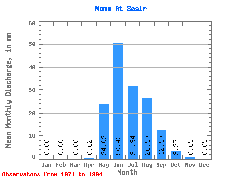
| Statistic | Jan | Feb | Mar | Apr | May | Jun | Jul | Aug | Sep | Oct | Nov | Dec | Annual |
|---|---|---|---|---|---|---|---|---|---|---|---|---|---|
| Mean | 0.00 | 0.00 | 0.00 | 0.62 | 24.01 | 50.42 | 31.94 | 26.56 | 12.57 | 3.27 | 0.65 | 0.05 | 148.66 |
| Standard Deviation | 0.00 | 0.00 | 0.00 | 2.13 | 12.75 | 27.66 | 17.75 | 13.14 | 6.50 | 3.25 | 1.66 | 0.21 | 58.56 |
| Min | 0.00 | 0.00 | 0.00 | 0.00 | 4.41 | 6.62 | 1.93 | 1.20 | 0.79 | 0.00 | 0.00 | 0.00 | 20.44 |
| Max | 0.00 | 0.00 | 0.00 | 10.08 | 51.84 | 120.74 | 75.76 | 49.78 | 23.82 | 13.62 | 7.87 | 0.97 | 242.60 |
| Coefficient of Variation | 3.43 | 0.53 | 0.55 | 0.56 | 0.49 | 0.52 | 0.99 | 2.57 | 4.25 | 0.39 |
 Return to R-Arctic Net Home Page