|
|
|||||||||||||||||
| Point ID: 6311 | Downloads | Plots | Site Data | Code: 3536 |
|
|
|||||||||||||||||
| Download | |
|---|---|
| Site Descriptor Information | Site Time Series Data |
| Link to all available data | |
| View: | Time Series | All |
| Units: | mm |
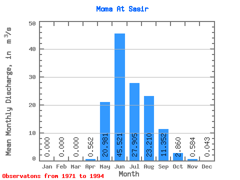
| Statistic | Jan | Feb | Mar | Apr | May | Jun | Jul | Aug | Sep | Oct | Nov | Dec | Annual |
|---|---|---|---|---|---|---|---|---|---|---|---|---|---|
| Mean | 0.00 | 0.00 | 0.00 | 0.56 | 20.98 | 45.52 | 27.91 | 23.21 | 11.35 | 2.86 | 0.58 | 0.04 | 11.02 |
| Standard Deviation | 0.00 | 0.00 | 0.00 | 1.93 | 11.14 | 24.97 | 15.51 | 11.48 | 5.87 | 2.84 | 1.50 | 0.18 | 4.34 |
| Min | 0.00 | 0.00 | 0.00 | 0.00 | 3.85 | 5.98 | 1.69 | 1.05 | 0.71 | 0.00 | 0.00 | 0.00 | 1.52 |
| Max | 0.00 | 0.00 | 0.00 | 9.10 | 45.30 | 109.00 | 66.20 | 43.50 | 21.50 | 11.90 | 7.10 | 0.85 | 17.99 |
| Coefficient of Variation | 3.43 | 0.53 | 0.55 | 0.56 | 0.49 | 0.52 | 0.99 | 2.57 | 4.25 | 0.39 |
 Return to R-Arctic Net Home Page