|
|
|||||||||||||||||
| Point ID: 6299 | Downloads | Plots | Site Data | Code: 3468 |
|
|
|||||||||||||||||
| Download | |
|---|---|
| Site Descriptor Information | Site Time Series Data |
| Link to all available data | |
| View: | Time Series | All |
| Units: | m3/s |
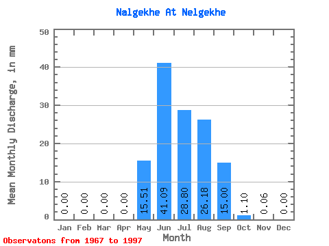
| Statistic | Jan | Feb | Mar | Apr | May | Jun | Jul | Aug | Sep | Oct | Nov | Dec | Annual |
|---|---|---|---|---|---|---|---|---|---|---|---|---|---|
| Mean | 0.00 | 0.00 | 0.00 | 0.00 | 15.51 | 41.09 | 28.79 | 26.18 | 15.00 | 1.10 | 0.06 | 0.00 | 127.27 |
| Standard Deviation | 0.00 | 0.00 | 0.00 | 0.00 | 11.88 | 23.58 | 16.02 | 11.87 | 21.49 | 0.97 | 0.10 | 0.01 | 53.82 |
| Min | 0.00 | 0.00 | 0.00 | 0.00 | 0.24 | 11.02 | 7.98 | 5.32 | 3.07 | -0.60 | -0.03 | 0.00 | 52.35 |
| Max | 0.00 | 0.00 | 0.00 | 0.00 | 58.85 | 110.84 | 68.54 | 54.79 | 126.02 | 4.28 | 0.38 | 0.04 | 323.54 |
| Coefficient of Variation | 0.77 | 0.57 | 0.56 | 0.45 | 1.43 | 0.89 | 1.79 | 5.33 | 0.42 |
 Return to R-Arctic Net Home Page