|
|
|||||||||||||||||
| Point ID: 6299 | Downloads | Plots | Site Data | Code: 3468 |
|
|
|||||||||||||||||
| Download | |
|---|---|
| Site Descriptor Information | Site Time Series Data |
| Link to all available data | |
| View: | Time Series | All |
| Units: | mm |
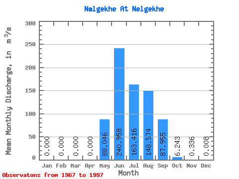
| Statistic | Jan | Feb | Mar | Apr | May | Jun | Jul | Aug | Sep | Oct | Nov | Dec | Annual |
|---|---|---|---|---|---|---|---|---|---|---|---|---|---|
| Mean | 0.00 | 0.00 | 0.00 | 0.00 | 88.05 | 240.96 | 163.42 | 148.57 | 87.95 | 6.24 | 0.34 | 0.01 | 61.30 |
| Standard Deviation | 0.00 | 0.00 | 0.00 | 0.00 | 67.43 | 138.30 | 90.92 | 67.38 | 126.02 | 5.53 | 0.60 | 0.04 | 25.92 |
| Min | 0.00 | 0.00 | 0.00 | 0.00 | 1.37 | 64.60 | 45.30 | 30.20 | 18.00 | -3.43 | -0.19 | 0.00 | 25.21 |
| Max | 0.00 | 0.00 | 0.00 | 0.00 | 334.00 | 650.00 | 389.00 | 311.00 | 739.00 | 24.30 | 2.24 | 0.23 | 155.82 |
| Coefficient of Variation | 0.77 | 0.57 | 0.56 | 0.45 | 1.43 | 0.89 | 1.79 | 5.33 | 0.42 |
 Return to R-Arctic Net Home Page