|
|
|||||||||||||||||
| Point ID: 6283 | Downloads | Plots | Site Data | Code: 3388 |
|
|
|||||||||||||||||
| Download | |
|---|---|
| Site Descriptor Information | Site Time Series Data |
| Link to all available data | |
| View: | Time Series | All |
| Units: | m3/s |
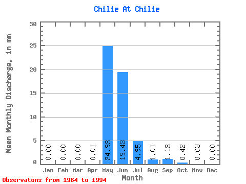
| Statistic | Jan | Feb | Mar | Apr | May | Jun | Jul | Aug | Sep | Oct | Nov | Dec | Annual |
|---|---|---|---|---|---|---|---|---|---|---|---|---|---|
| Mean | 0.00 | 0.00 | 0.00 | 0.01 | 24.93 | 19.43 | 4.95 | 1.01 | 1.13 | 0.42 | 0.03 | 0.00 | 50.85 |
| Standard Deviation | 0.00 | 0.00 | 0.00 | 0.02 | 13.43 | 13.36 | 7.67 | 1.97 | 2.23 | 0.66 | 0.07 | 0.01 | 30.00 |
| Min | 0.00 | 0.00 | 0.00 | 0.00 | 3.99 | 2.73 | 0.46 | 0.03 | 0.01 | 0.00 | 0.00 | 0.00 | 14.03 |
| Max | 0.00 | 0.00 | 0.00 | 0.09 | 51.61 | 52.51 | 39.09 | 10.36 | 9.16 | 2.43 | 0.34 | 0.02 | 149.25 |
| Coefficient of Variation | 3.39 | 0.54 | 0.69 | 1.55 | 1.95 | 1.98 | 1.56 | 2.01 | 3.21 | 0.59 |
 Return to R-Arctic Net Home Page