|
|
|||||||||||||||||
| Point ID: 6283 | Downloads | Plots | Site Data | Code: 3388 |
|
|
|||||||||||||||||
| Download | |
|---|---|
| Site Descriptor Information | Site Time Series Data |
| Link to all available data | |
| View: | Time Series | All |
| Units: | mm |
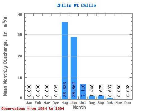
| Statistic | Jan | Feb | Mar | Apr | May | Jun | Jul | Aug | Sep | Oct | Nov | Dec | Annual |
|---|---|---|---|---|---|---|---|---|---|---|---|---|---|
| Mean | 0.00 | 0.00 | 0.00 | 0.01 | 35.83 | 28.86 | 7.12 | 1.45 | 1.68 | 0.61 | 0.05 | 0.00 | 6.20 |
| Standard Deviation | 0.00 | 0.00 | 0.00 | 0.03 | 19.31 | 19.84 | 11.03 | 2.83 | 3.31 | 0.95 | 0.10 | 0.01 | 3.66 |
| Min | 0.00 | 0.00 | 0.00 | 0.00 | 5.73 | 4.06 | 0.66 | 0.04 | 0.01 | 0.00 | 0.00 | 0.00 | 1.71 |
| Max | 0.00 | 0.00 | 0.00 | 0.13 | 74.20 | 78.00 | 56.20 | 14.90 | 13.60 | 3.49 | 0.50 | 0.03 | 18.21 |
| Coefficient of Variation | 3.39 | 0.54 | 0.69 | 1.55 | 1.95 | 1.98 | 1.56 | 2.01 | 3.21 | 0.59 |
 Return to R-Arctic Net Home Page