|
|
|||||||||||||||||
| Point ID: 6274 | Downloads | Plots | Site Data | Code: 3348 |
|
|
|||||||||||||||||
| Download | |
|---|---|
| Site Descriptor Information | Site Time Series Data |
| Link to all available data | |
| View: | Time Series | All |
| Units: | m3/s |
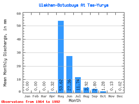
| Statistic | Jan | Feb | Mar | Apr | May | Jun | Jul | Aug | Sep | Oct | Nov | Dec | Annual |
|---|---|---|---|---|---|---|---|---|---|---|---|---|---|
| Mean | 0.00 | 0.00 | 0.00 | 0.32 | 53.61 | 27.36 | 11.74 | 3.92 | 2.80 | 1.28 | 0.13 | 0.02 | 100.39 |
| Standard Deviation | 0.01 | 0.00 | 0.00 | 1.36 | 21.87 | 19.73 | 13.82 | 10.20 | 3.53 | 1.68 | 0.20 | 0.04 | 42.92 |
| Min | 0.00 | 0.00 | 0.00 | 0.00 | 25.85 | 5.25 | 0.32 | 0.23 | 0.15 | 0.12 | 0.01 | 0.00 | 43.84 |
| Max | 0.06 | 0.00 | 0.00 | 7.13 | 108.80 | 85.65 | 53.97 | 54.55 | 14.18 | 7.37 | 1.02 | 0.17 | 201.75 |
| Coefficient of Variation | 3.23 | 4.18 | 0.41 | 0.72 | 1.18 | 2.60 | 1.26 | 1.31 | 1.59 | 1.71 | 0.43 |
 Return to R-Arctic Net Home Page