|
|
|||||||||||||||||
| Point ID: 6274 | Downloads | Plots | Site Data | Code: 3348 |
|
|
|||||||||||||||||
| Download | |
|---|---|
| Site Descriptor Information | Site Time Series Data |
| Link to all available data | |
| View: | Time Series | All |
| Units: | mm |
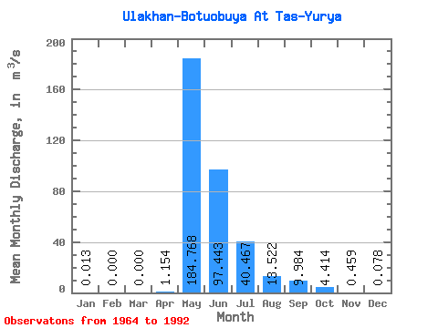
| Statistic | Jan | Feb | Mar | Apr | May | Jun | Jul | Aug | Sep | Oct | Nov | Dec | Annual |
|---|---|---|---|---|---|---|---|---|---|---|---|---|---|
| Mean | 0.01 | 0.00 | 0.00 | 1.15 | 184.77 | 97.44 | 40.47 | 13.52 | 9.98 | 4.41 | 0.46 | 0.08 | 29.36 |
| Standard Deviation | 0.04 | 0.00 | 0.00 | 4.83 | 75.36 | 70.26 | 47.64 | 35.14 | 12.58 | 5.80 | 0.73 | 0.13 | 12.55 |
| Min | 0.00 | 0.00 | 0.00 | 0.00 | 89.10 | 18.70 | 1.11 | 0.78 | 0.54 | 0.41 | 0.04 | 0.00 | 12.82 |
| Max | 0.22 | 0.00 | 0.00 | 25.40 | 375.00 | 305.00 | 186.00 | 188.00 | 50.50 | 25.40 | 3.63 | 0.59 | 59.00 |
| Coefficient of Variation | 3.23 | 4.18 | 0.41 | 0.72 | 1.18 | 2.60 | 1.26 | 1.31 | 1.59 | 1.71 | 0.43 |
 Return to R-Arctic Net Home Page