|
|
|||||||||||||||||
| Point ID: 6263 | Downloads | Plots | Site Data | Code: 3313 |
|
|
|||||||||||||||||
| Download | |
|---|---|
| Site Descriptor Information | Site Time Series Data |
| Link to all available data | |
| View: | Time Series | All |
| Units: | m3/s |
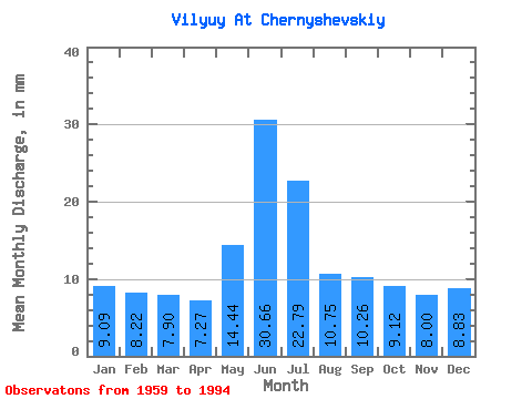
| Statistic | Jan | Feb | Mar | Apr | May | Jun | Jul | Aug | Sep | Oct | Nov | Dec | Annual |
|---|---|---|---|---|---|---|---|---|---|---|---|---|---|
| Mean | 9.09 | 8.29 | 7.90 | 7.27 | 14.44 | 30.66 | 22.78 | 10.75 | 10.26 | 9.12 | 8.00 | 8.83 | 148.78 |
| Standard Deviation | 6.92 | 6.00 | 5.73 | 6.28 | 14.96 | 26.13 | 11.98 | 11.02 | 7.10 | 5.09 | 5.64 | 6.46 | 43.87 |
| Min | 0.01 | 0.06 | 0.06 | 0.05 | 0.02 | 5.34 | 3.68 | 0.01 | 2.17 | 2.30 | 0.46 | 0.10 | 67.70 |
| Max | 18.61 | 16.38 | 15.32 | 31.26 | 51.39 | 109.97 | 49.42 | 46.67 | 36.59 | 27.77 | 15.67 | 16.62 | 258.88 |
| Coefficient of Variation | 0.76 | 0.72 | 0.72 | 0.86 | 1.04 | 0.85 | 0.53 | 1.02 | 0.69 | 0.56 | 0.70 | 0.73 | 0.29 |
 Return to R-Arctic Net Home Page