|
|
|||||||||||||||||
| Point ID: 6263 | Downloads | Plots | Site Data | Code: 3313 |
|
|
|||||||||||||||||
| Download | |
|---|---|
| Site Descriptor Information | Site Time Series Data |
| Link to all available data | |
| View: | Time Series | All |
| Units: | mm |
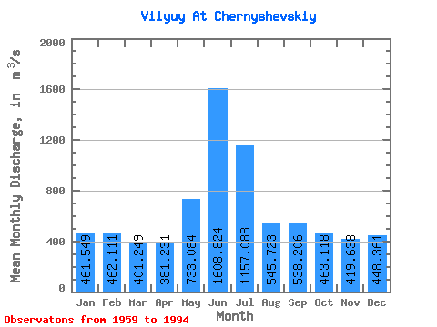
| Statistic | Jan | Feb | Mar | Apr | May | Jun | Jul | Aug | Sep | Oct | Nov | Dec | Annual |
|---|---|---|---|---|---|---|---|---|---|---|---|---|---|
| Mean | 461.55 | 462.11 | 401.25 | 381.23 | 733.08 | 1608.82 | 1157.09 | 545.72 | 538.21 | 463.12 | 419.64 | 448.36 | 641.14 |
| Standard Deviation | 351.59 | 334.45 | 291.05 | 329.65 | 759.52 | 1371.20 | 608.27 | 559.52 | 372.35 | 258.32 | 295.75 | 328.12 | 189.05 |
| Min | 0.75 | 3.12 | 2.95 | 2.79 | 0.86 | 280.00 | 187.00 | 0.57 | 114.00 | 117.00 | 24.00 | 5.12 | 291.75 |
| Max | 945.00 | 913.00 | 778.00 | 1640.00 | 2610.00 | 5770.00 | 2510.00 | 2370.00 | 1920.00 | 1410.00 | 822.00 | 844.00 | 1115.58 |
| Coefficient of Variation | 0.76 | 0.72 | 0.72 | 0.86 | 1.04 | 0.85 | 0.53 | 1.02 | 0.69 | 0.56 | 0.70 | 0.73 | 0.29 |
 Return to R-Arctic Net Home Page