|
|
|||||||||||||||||
| Point ID: 6253 | Downloads | Plots | Site Data | Code: 3286 |
|
|
|||||||||||||||||
| Download | |
|---|---|
| Site Descriptor Information | Site Time Series Data |
| Link to all available data | |
| View: | Time Series | All |
| Units: | m3/s |
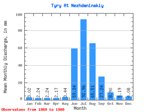
| Statistic | Jan | Feb | Mar | Apr | May | Jun | Jul | Aug | Sep | Oct | Nov | Dec | Annual |
|---|---|---|---|---|---|---|---|---|---|---|---|---|---|
| Mean | 3.02 | 2.26 | 2.24 | 2.17 | 3.44 | 59.34 | 92.95 | 65.50 | 27.24 | 8.90 | 5.19 | 4.08 | 268.71 |
| Standard Deviation | 1.09 | 0.65 | 0.68 | 0.79 | 1.55 | 36.82 | 37.56 | 36.65 | 20.61 | 4.54 | 1.44 | 1.55 | 84.31 |
| Min | 1.09 | 1.09 | 0.90 | 0.79 | 1.04 | 1.76 | 45.23 | 8.55 | 5.34 | 3.15 | 2.25 | 1.46 | 141.91 |
| Max | 6.52 | 3.64 | 3.70 | 4.54 | 7.00 | 125.26 | 187.08 | 144.79 | 86.19 | 24.73 | 7.89 | 8.05 | 487.54 |
| Coefficient of Variation | 0.36 | 0.29 | 0.30 | 0.36 | 0.45 | 0.62 | 0.40 | 0.56 | 0.76 | 0.51 | 0.28 | 0.38 | 0.31 |
 Return to R-Arctic Net Home Page