|
|
|||||||||||||||||
| Point ID: 6253 | Downloads | Plots | Site Data | Code: 3286 |
|
|
|||||||||||||||||
| Download | |
|---|---|
| Site Descriptor Information | Site Time Series Data |
| Link to all available data | |
| View: | Time Series | All |
| Units: | mm |
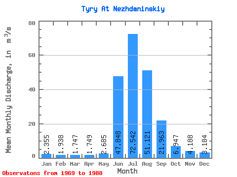
| Statistic | Jan | Feb | Mar | Apr | May | Jun | Jul | Aug | Sep | Oct | Nov | Dec | Annual |
|---|---|---|---|---|---|---|---|---|---|---|---|---|---|
| Mean | 2.35 | 1.94 | 1.75 | 1.75 | 2.69 | 47.85 | 72.54 | 51.12 | 21.96 | 6.95 | 4.19 | 3.18 | 17.80 |
| Standard Deviation | 0.85 | 0.56 | 0.53 | 0.64 | 1.21 | 29.69 | 29.32 | 28.60 | 16.62 | 3.54 | 1.16 | 1.21 | 5.58 |
| Min | 0.85 | 0.93 | 0.70 | 0.64 | 0.81 | 1.42 | 35.30 | 6.67 | 4.31 | 2.46 | 1.81 | 1.14 | 9.40 |
| Max | 5.09 | 3.12 | 2.89 | 3.66 | 5.46 | 101.00 | 146.00 | 113.00 | 69.50 | 19.30 | 6.36 | 6.28 | 32.29 |
| Coefficient of Variation | 0.36 | 0.29 | 0.30 | 0.36 | 0.45 | 0.62 | 0.40 | 0.56 | 0.76 | 0.51 | 0.28 | 0.38 | 0.31 |
 Return to R-Arctic Net Home Page