|
|
|||||||||||||||||
| Point ID: 6230 | Downloads | Plots | Site Data | Code: 3217 |
|
|
|||||||||||||||||
| Download | |
|---|---|
| Site Descriptor Information | Site Time Series Data |
| Link to all available data | |
| View: | Time Series | All |
| Units: | m3/s |
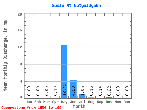
| Statistic | Jan | Feb | Mar | Apr | May | Jun | Jul | Aug | Sep | Oct | Nov | Dec | Annual |
|---|---|---|---|---|---|---|---|---|---|---|---|---|---|
| Mean | 0.00 | 0.00 | 0.00 | 0.10 | 12.41 | 4.23 | 1.05 | 0.15 | 0.14 | 0.22 | 0.00 | 0.00 | 18.39 |
| Standard Deviation | 0.00 | 0.00 | 0.00 | 0.45 | 17.30 | 5.94 | 2.49 | 0.38 | 0.36 | 1.08 | 0.01 | 0.00 | 21.51 |
| Min | 0.00 | 0.00 | 0.00 | 0.00 | 0.08 | 0.01 | 0.00 | 0.00 | 0.00 | 0.00 | 0.00 | 0.00 | 0.41 |
| Max | 0.00 | 0.00 | 0.00 | 2.84 | 70.85 | 27.96 | 14.51 | 2.38 | 2.06 | 6.89 | 0.03 | 0.00 | 85.11 |
| Coefficient of Variation | 4.71 | 1.39 | 1.41 | 2.38 | 2.49 | 2.61 | 5.03 | 4.06 | 1.17 |
 Return to R-Arctic Net Home Page